Archive

Posts Tagged ‘Colonial America’

Edward Grantham of Isle of Wight County

December 15th, 2009 No comments

Surry Land Patents 1614 - 1666

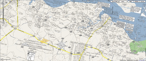
You remember this map? It’s an overlay of a Surry Land Patent Map from 1614 – 1666. It showed where John Roger’s held 200 acres of land he was granted on May 14, 1666. He later deeded this property (highlighted on the map where it is likely to be) to Edward Grantham where 1694 he was the subject of a presentation by the Grand Jury for “Entertaining Indians contrary to Law & for not comeing to church.”

Edward bought 200 acres in Surry County on September 23, 1682, from John Rodgers, Sr., and his wife Mary.  The land was purchased for 1,000 pounds of tobacco with the contract written on the back of the land patent that had been issued to Rodgers in 1666 by Governor William Berkeley.

Edward sold 100 acres of this land to William Jonson in 1684 for 1,650 pounds of tobacco. The other 100 acres and “40 foot dwelling” was sold to Thomas Davis in 1686 for 3,500 pounds of tobacco.

Edward received a land patent of 300 acres on May 29, 1683. The land was located in Southwarke Parish, Surry County, on the branches of Cypress Swamp adjoining Thos. Jordan. The patent was granted for the transportation of six persons into the colony: Isabel Huberd, Jon. Bincks, Tho. Peel, Jon. Anderson, Jon. Walker, & Timo. Jackson. Edward Grantham’s property on Cypress Swamp was known as Grantham’s Reeds. Many of the deeds concerning this land mention the “cart path,” which was actually a well traveled road leading from North Carolina to Southwarke Church and the warehouses at Gray’s Creek.

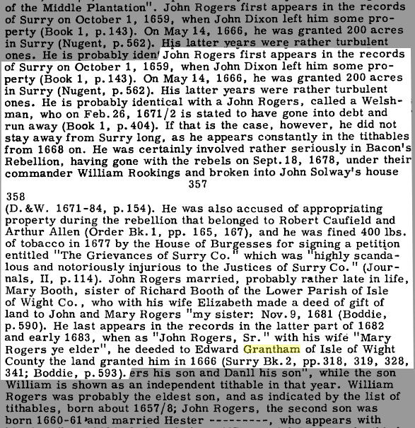
Here’s a passage about John Rogers from Southside Virginia Families, Volume 2 by John Bennett Boddie noting his role in Bacon’s Rebellion.

surryland

Here’s a much longer account of Sir Thomas Grantham’s role in the Bacon Rebellion shared with me today by someone who shared an interest in Edward Grantham in particular.

Grantham’s Reeds: Colonial Virginia Land Map

November 20th, 2008 1 comment

surrypatent.jpg

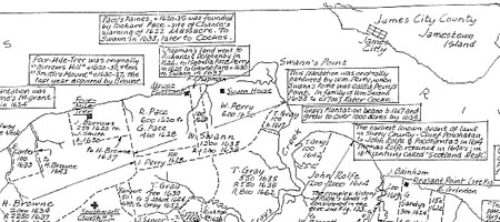
Somewhere among these Surry County Virginia land patents from the 1600s is the 200 acres Edward Grantham bought. This map showed the area 20 years prior to the purchase mentioned below. He sold the property a couple of years later for a good profit and got a new land patent. That property was known as Grantham’s Reeds.

Edward bought 200 acres in Surry County on September 23, 1682, from John Rodgers, Sr., and his wife Mary.  The land was purchased for 1,000 pounds of tobacco with the contract written on the back of the land patent that had been issued to Rodgers in 1666 by Governor William Berkeley.

Edward sold 100 acres of this land to William Jonson in 1684 for 1,650 pounds of tobacco. The other 100 acres and “40 foot dwelling” was sold to Thomas Davis in 1686 for 3,500 pounds of tobacco.

Edward received a land patent of 300 acres on May 29, 1683. The land was located in Southwarke Parish, Surry County, on the branches of Cypress Swamp adjoining Thos. Jordan. The patent was granted for the transportation of six persons into the colony: Isabel Huberd, Jon. Bincks, Tho. Peel, Jon. Anderson, Jon. Walker, & Timo. Jackson. Edward Grantham’s property on Cypress Swamp was known as Grantham’s Reeds. Many of the deeds concerning this land mention the “cart path,” which was actually a well traveled road leading from North Carolina to Southwarke Church and the warehouses at Gray’s Creek.

surrypatentgoogmapx450.jpg

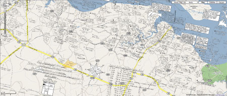
After scanning over the map, I found the 200 acres owned by John Rodgers. I pulled up a Google map of the land directly across from Jamestown, VA and then overlaid the old patent map. It was tough getting them to line up, but I moved it back and forth until some nearby creeks met and there it is, the first 200 acre property. I highlighted the area in yellow. Here’s the satellite view. I’m still looking for Grantham’s Reed.